Click below to generate summary
Have you ever wondered why India looks so incredibly diverse — with snow-capped peaks in the north, vast fertile plains in the middle, ancient rocky plateaus in the south, golden deserts in the west, and long stretches of coastline on both sides? The answer lies in the major physiographic divisions of India, a foundational concept in Indian geography that every student, traveler, and curious mind should understand.
India is not just a country — it is a geographical marvel. Spanning over 3.2 million square kilometers, it hosts nearly every type of landform found on Earth. From the world's youngest and highest mountain range — the Himalayas — to one of the most ancient rock formations on the planet — the Peninsular Plateau — India's terrain tells a story billions of years in the making.
Understanding India's physiographic divisions is important not just for examinations, but for grasping why certain rivers flow in specific directions, why certain regions receive more rainfall, why certain areas are agriculturally rich, and why biodiversity hotspots are concentrated in particular zones. Physiography directly shapes the climate, economy, lifestyle, and culture of the people who inhabit these regions.
What is Physiography?
Physiography, derived from the Greek words physis (nature) and graphia (writing/description), refers to the scientific study and description of the physical features of the Earth's surface. It is essentially a branch of physical geography that focuses on landforms, terrain types, and the natural processes that shape them over time.
In the context of India, physiography means understanding how the land is structured — what kinds of landforms exist, how they were formed, and what role they play in shaping the country's natural environment.
Key Points:
- Physiography = study of natural landforms and terrain
- It combines elements of geology, climatology, and geography
- India's physiography is shaped by tectonic activity, river erosion, wind action, and ancient geological forces
- It influences climate zones, agricultural potential, river systems, and human settlement patterns
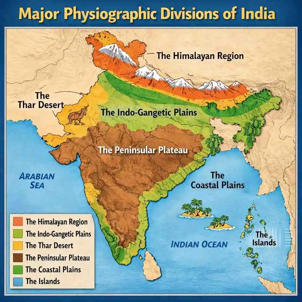
Overview of the 6 Major Physiographic Divisions of India
India can be divided into six broad physiographic regions, each with its own unique geological history, climate, and ecological character.
Quick Summary Bullets:
- These six divisions represent the complete geographical personality of India
- Each division has distinct soil types, vegetation, rainfall patterns, and river systems
- Together, they support over 1.4 billion people with diverse livelihoods
The Himalayan Mountains
The Himalayan Mountains form the northern boundary of India and are one of the most iconic and important geographical features in the world. The word "Himalaya" comes from Sanskrit — hima (snow) and alaya (abode) — meaning "Abode of Snow." These mountains are geologically young, formed roughly 50 million years ago when the Indo-Australian tectonic plate collided with the Eurasian plate. This ongoing collision is why the Himalayas continue to rise very slowly even today.
Stretching approximately 2,500 kilometers across India, Nepal, Bhutan, and Pakistan, the Himalayas act as a giant climatic wall. They block cold Arctic winds from entering the Indian subcontinent and trap the monsoon clouds, forcing them to release heavy rainfall over the Indo-Gangetic Plain. Without the Himalayas, northern India would be a much colder and drier region.
The Himalayas are home to some of the world's highest peaks, including Mount Everest (8,849 m), Kanchenjunga (8,586 m), and Nanda Devi (7,816 m) — the highest peak entirely within India. These mountains also serve as the source of major perennial rivers like the Ganga, Yamuna, Indus, and Brahmaputra.
Key Points:
- Age: Approximately 50 million years old (geologically young)
- Length: ~2,500 km across northern India
- Acts as a climatic barrier protecting India from cold Central Asian winds
- Source of major rivers that sustain hundreds of millions of people
- Rich in biodiversity, glaciers, and mineral resources
Subdivisions of the Himalayas
The Himalayas are not a single mountain range but a series of parallel ranges arranged from north to south:
1. The Greater Himalayas (Himadri): The northernmost and highest range, with an average elevation exceeding 6,000 meters. This is where the highest peaks are located. The range is always covered in snow and contains several important glaciers, including the Gangotri and Zemu glaciers.
2. The Lesser Himalayas (Himachal): Located south of the Greater Himalayas, with elevations ranging from 3,700 to 4,500 meters. Popular hill stations like Shimla, Mussoorie, Nainital, and Darjeeling are found here. This range also contains important valleys and forested slopes.
3. The Shiwalik Range (Outer Himalayas): The southernmost and youngest range, with elevations between 900 and 1,100 meters. The Shiwaliks are separated from the Lesser Himalayas by longitudinal valleys called duns, such as the Dehradun Valley. This range is more prone to erosion and landslides due to its loose geological structure.
Key Points:
- Three parallel ranges: Himadri, Himachal, Shiwalik
- Each range differs in elevation, rock type, and vegetation
- Duns (longitudinal valleys) lie between the ranges
- Major hill stations and tourist destinations located in Lesser Himalayas
The Northern Plains
The Northern Plains of India — also called the Indo-Gangetic Plain or the Great Plains — stretch from Punjab in the west to Assam in the east, covering an area of approximately 7 lakh square kilometers. These plains were formed over millions of years through the deposition of alluvial sediments carried down from the Himalayas by rivers. The depth of alluvial deposits in this region can be as much as 1,000 to 2,000 meters in some places.
This region is the agricultural heartland of India. The soil is incredibly fertile — enriched with minerals washed down from the Himalayan mountains — making it one of the most productive agricultural zones in the world. Crops like wheat, rice, sugarcane, mustard, and pulses are grown extensively here. The Northern Plains also account for the majority of India's population, housing some of the country's largest cities including Delhi, Lucknow, Patna, and Kolkata.
The plains are relatively flat and gently sloping, which has historically made them easy to settle, cultivate, and connect through road and rail networks. The Northern Plains are also culturally and historically significant — many ancient civilizations, empires, and trade routes flourished across this terrain.
Key Points:
- Formed by alluvial deposition from Himalayan rivers
- One of the most fertile agricultural regions in the world
- Covers Punjab, Haryana, UP, Bihar, and parts of West Bengal and Assam
- Dense population and major urban centers
- Low elevation, flat terrain ideal for farming and transport
River Systems of the Northern Plains
Three major river systems drain the Northern Plains:
1. The Indus River System: Originates in Tibet and flows through Ladakh before entering Pakistan. Major tributaries in India include the Jhelum, Chenab, Ravi, Beas, and Sutlej — rivers that form the backbone of the Punjab agricultural economy.
2. The Ganga River System: India's most sacred and largest river system. The Ganga originates at Gangotri Glacier and is joined by numerous tributaries like the Yamuna, Ghaghra, Gandak, and Son. It flows eastward through Uttarakhand, UP, Bihar, and West Bengal before emptying into the Bay of Bengal.
3. The Brahmaputra River System: One of the world's largest rivers by discharge volume. It originates in Tibet (where it is called Tsangpo), enters India through Arunachal Pradesh, flows westward through Assam, and joins the Ganga delta in Bangladesh.
Key Points:
- Three systems: Indus (west), Ganga (central), Brahmaputra (east)
- All three are perennial rivers fed by Himalayan glaciers
- They support irrigation, drinking water, and livelihoods for hundreds of millions
- Ganga-Brahmaputra delta is the world's largest river delta
The Peninsular Plateau
The Peninsular Plateau is the oldest and most stable landmass in India, forming the core of the Indian subcontinent. It is part of the ancient Gondwanaland — the supercontinent that broke apart over 150 million years ago. The plateau is made primarily of hard igneous and metamorphic rocks, making it geologically stable and resistant to seismic activity.
The Peninsular Plateau covers a vast triangular area south of the Northern Plains and is bounded by the Aravalli Hills in the northwest, the Vindhya and Satpura ranges in the north, and the Eastern and Western Ghats on the margins. The general elevation is between 600 and 900 meters above sea level, though it rises higher in some areas.
This region is rich in mineral resources — coal, iron ore, manganese, copper, and bauxite — making it India's mineral storehouse and the hub of heavy industries.
Key Points:
- Oldest geological formation in India (part of Gondwanaland)
- Made of hard igneous and metamorphic rocks
- Rich in mineral resources: coal, iron ore, bauxite, manganese
- Generally flat to gently undulating terrain
- Source of peninsular rivers: Godavari, Krishna, Kaveri, Narmada, Tapi
The Central Highlands
The northern section of the Peninsular Plateau is known as the Central Highlands. This area lies north of the Narmada River and includes the Malwa Plateau, Chhota Nagpur Plateau, and the Bundelkhand uplands. The terrain here slopes gently northward, and rivers like the Chambal, Betwa, and Ken drain into the Ganga system.
Key Points:
- Located north of Narmada River
- Includes Malwa Plateau and Chhota Nagpur Plateau
- Chhota Nagpur is India's richest mineral belt
- Forests cover significant portions of this sub-region
The Deccan Plateau
The southern and larger section of the Peninsular Plateau is the Deccan Plateau, which covers most of peninsular India south of the Narmada. It slopes generally from west to east, which is why most Deccan rivers like the Godavari, Krishna, and Kaveri flow eastward into the Bay of Bengal. The plateau is flanked by the Western Ghats in the west and the Eastern Ghats in the east.
The Deccan Trap — a large area covered by ancient lava flows — has produced some of India's most fertile black soil (called regur or cotton soil), especially in Maharashtra, which is why Maharashtra is a major cotton-growing state.
Key Points:
- Slopes eastward, rivers drain into Bay of Bengal
- Flanked by Western Ghats (west) and Eastern Ghats (east)
- Black lava soil (regur) is ideal for cotton cultivation
- Includes the states of Maharashtra, Karnataka, Telangana, and Andhra Pradesh
The Indian Desert (Thar Desert)
Located in the northwestern corner of India — primarily in Rajasthan — the Thar Desert is the seventh largest desert in the world and the most densely populated desert on Earth. It extends into parts of Gujarat and into Pakistan. The desert covers approximately 2 lakh square kilometers and is characterized by rolling sand dunes, sparse vegetation, extreme temperatures, and very low annual rainfall (below 150 mm).
Despite its harsh conditions, the Thar Desert is home to a remarkable array of wildlife, including the Great Indian Bustard, desert foxes, and blackbucks. The region also has rich cultural heritage — Rajasthan's colorful festivals, forts, and folk traditions are deeply rooted in desert life.
In recent years, the Thar has become a focus of solar energy development, given its vast uninhabited land and high solar radiation levels.
Key Points:
- Covers ~2 lakh sq km in Rajasthan and parts of Gujarat
- Annual rainfall below 150 mm
- Extreme temperature range: very hot days, cold nights
- Rich cultural heritage and biodiversity despite harsh conditions
- Emerging hub for solar power generation
The Coastal Plains
India has a coastline stretching over 7,500 kilometers, divided into two distinct coastal plains — the Western Coastal Plains and the Eastern Coastal Plains — separated by the Peninsular Plateau.
Western Coastal Plains: Narrow, extending from Gujarat to Kerala, bounded by the Arabian Sea in the west and the Western Ghats in the east. This coast includes the famous Konkan Coast (Maharashtra and Goa), Malabar Coast (Kerala), and Coromandel's western counterpart. It is characterized by estuaries, lagoons, and backwaters. Kerala's backwaters are a globally recognized feature of this coast.
Eastern Coastal Plains: Wider than the western coast, stretching from West Bengal to Tamil Nadu along the Bay of Bengal. This coast includes river deltas of the Mahanadi, Godavari, Krishna, and Kaveri — forming fertile delta plains ideal for rice cultivation. The Chilika Lake in Odisha, the largest coastal lagoon in India, is located here.
Key Points:
- Total coastline: over 7,500 km
- Western coast: narrow, estuaries, backwaters, ports like Mumbai and Kochi
- Eastern coast: wider, fertile river deltas, rice cultivation
- Both coasts support fishing, trade, and tourism industries
- Coastal cities like Mumbai, Chennai, Kochi, and Visakhapatnam are economic powerhouses
The Islands
India's island territories are divided into two major groups:
1. Andaman and Nicobar Islands: Located in the Bay of Bengal, this archipelago consists of over 572 islands, of which only about 38 are inhabited. The islands are covered in dense tropical rainforests and are home to unique tribal communities like the Sentinelese, Jarawas, and Onge. The highest point is Saddle Peak (732 m). Port Blair is the capital and main urban center.
2. Lakshadweep Islands: Located in the Arabian Sea, west of Kerala, Lakshadweep is India's smallest Union Territory by area. It consists of 36 coral islands, atolls, and reefs. The islands are known for their crystal-clear lagoons, white sand beaches, and rich marine biodiversity, including coral reefs and sea turtles.
Key Points:
- Andaman & Nicobar: Bay of Bengal, volcanic origin, dense tropical forests
- Lakshadweep: Arabian Sea, coral origin, pristine marine ecosystem
- Both are Union Territories administered directly by the central government
- Important for strategic maritime security and eco-tourism
Importance of Physiographic Divisions of India
The six physiographic divisions of India are not merely academic categories — they have deep, real-world importance across multiple dimensions:
Climate: The Himalayas act as a climatic barrier that defines India's monsoon system, temperature zones, and precipitation patterns. The coastal plains and islands are influenced by sea breezes and cyclonic activity.
Agriculture: The Northern Plains and delta regions are among the most productive agricultural zones in the world. Different physiographic regions support different crops — wheat and rice in the plains, cotton on the Deccan Plateau, spices and coconut on coastal plains.
Economy: The Peninsular Plateau's mineral wealth powers India's steel, coal, and manufacturing industries. Coastal plains enable maritime trade, fisheries, and port economies. The Thar Desert is emerging as a solar energy hub.
Biodiversity: India's physiographic diversity supports extraordinary biodiversity — from Himalayan snow leopards to Thar Desert wolves, from Andaman's coral ecosystems to Western Ghats' endemic plant species. The Western Ghats are a designated UNESCO Biodiversity Hotspot.
Key Points:
- Himalayas shape India's monsoon and water supply
- Northern Plains feed the nation
- Peninsular Plateau provides mineral and industrial base
- Islands and coasts support trade and marine economy
- Physiographic diversity = extraordinary biodiversity
FAQs: Major Physiographic Divisions of India
Q1. How many physiographic divisions does India have?
India has six major physiographic divisions: the Himalayan Mountains, the Northern Plains, the Peninsular Plateau, the Indian Desert (Thar), the Coastal Plains, and the Islands. Each division has distinct geological origins, terrain features, and ecological characteristics that together make India one of the most geographically diverse countries on Earth.
Q2. Which is the oldest physiographic division of India?
The Peninsular Plateau is the oldest physiographic division of India. It is a part of the ancient Gondwanaland supercontinent and is composed of Precambrian igneous and metamorphic rocks. It has been geologically stable for hundreds of millions of years, making it one of the oldest landmasses on Earth.
Q3. Why are the Northern Plains of India so fertile?
The Northern Plains are formed by the alluvial deposition of sediments brought by Himalayan rivers over millions of years. This deep, rich alluvial soil — packed with minerals, nutrients, and fine silt — makes the region extraordinarily fertile. Perennial rivers ensure a reliable water supply, making it ideal for year-round cultivation of crops like wheat, rice, and sugarcane.
Q4. What is the significance of the Western and Eastern Ghats?
The Western Ghats and Eastern Ghats flank the Peninsular Plateau. The Western Ghats are a major UNESCO Biodiversity Hotspot and act as an orographic barrier that causes heavy rainfall on the windward side. The Eastern Ghats are older, more eroded, and less continuous. Together, they form the boundary of the Deccan Plateau and influence rainfall distribution across southern India.
Q5. Which Indian islands are part of the coral origin?
The Lakshadweep Islands in the Arabian Sea are of coral origin, formed from coral reefs and atolls over thousands of years. In contrast, the Andaman and Nicobar Islands in the Bay of Bengal are of volcanic and sedimentary origin. The coral ecosystems of Lakshadweep are among the most pristine and biodiverse marine habitats in the Indian Ocean.
Conclusion
India's six major physiographic divisions — the Himalayan Mountains, Northern Plains, Peninsular Plateau, Indian Desert, Coastal Plains, and Islands — together form one of the most geographically rich and varied nations on Earth. From the glaciated heights of the Himalayas to the warm turquoise waters surrounding the Andaman Islands, each division has its own geological story, ecological personality, and economic significance.
Understanding these divisions helps us appreciate why India's rivers flow the way they do, why its climate varies so dramatically from region to region, why certain crops grow in specific areas, and how millions of people have adapted their lives to remarkably different environments. For students, mastering this topic is essential — it forms the foundation of India's physical geography curriculum and appears in virtually every competitive examination.
The physiographic diversity of India is not just a geographical fact — it is the very source of the country's agricultural wealth, mineral richness, cultural variety, and biodiversity. India's land is its greatest asset, shaped over billions of years into the extraordinary landscape we see and inhabit today.
Studylab24
100 Like · 4K views