India is a country known for its extraordinary geographical diversity. The land stretches from snow-covered mountains in the north to tropical coastal regions in the south, creating a remarkable range of landscapes and ecosystems. These landscapes have developed over millions of years due to geological movements, climatic influences, and river systems that shaped the land into different physiographic regions.
The natural environment of the Indian subcontinent plays an important role in determining climate, vegetation, agriculture, settlement patterns, and economic activities. Mountains influence rainfall patterns, plains support intensive agriculture, plateaus contain mineral resources, deserts demonstrate unique adaptations to arid conditions, and coastal areas connect the country to maritime routes. Islands further extend the geographical boundary into surrounding seas and contribute to biodiversity.
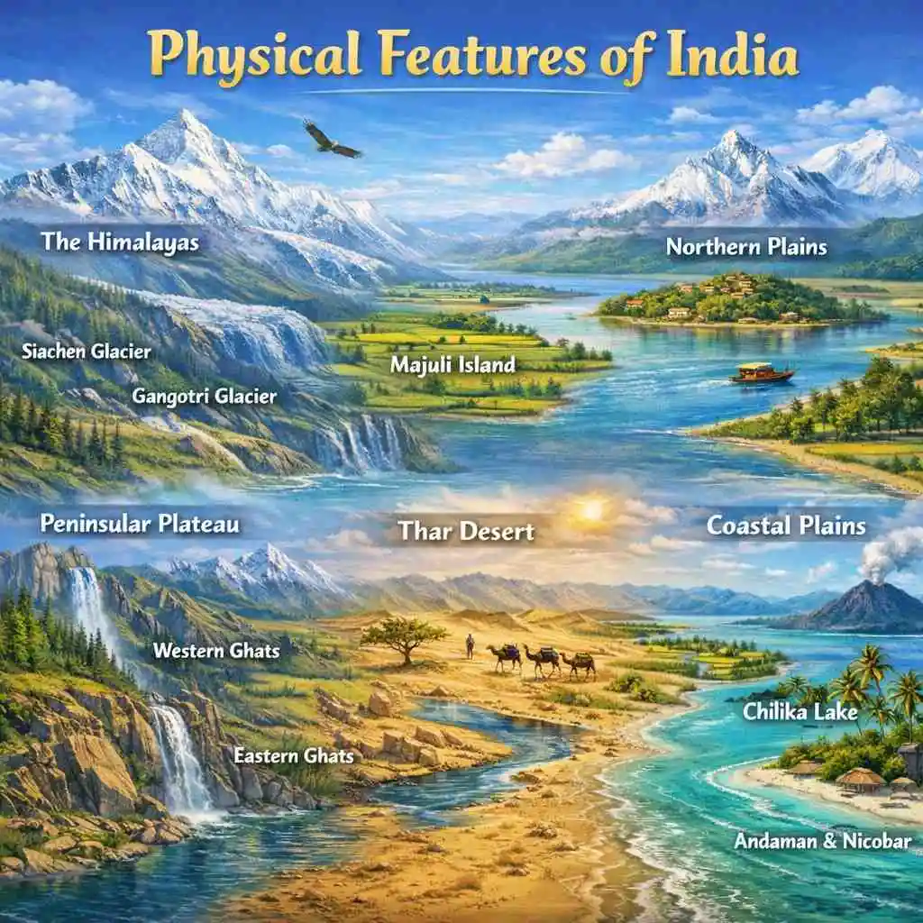
Geographers generally divide the country into six major physiographic divisions: the Himalayan Mountains, the Northern Plains, the Peninsular Plateau, the Indian Desert, the Coastal Plains, and the Islands. Each region has distinctive geological features, landforms, and environmental characteristics that contribute to the overall physical landscape.
Understanding these regions provides valuable insight into the natural structure of the subcontinent and explains how geography influences the life and development of the nation.
The Himalayan Mountains
The Himalayan mountain system forms the northernmost physical barrier of the Indian subcontinent and stands as one of the most prominent natural features in the world. These mountains are known for their extraordinary height, rugged terrain, and dramatic landscapes that stretch across several countries in Asia. In India, the Himalayas create a protective wall that separates the subcontinent from the cold deserts of Central Asia.
From a geological perspective, the Himalayas are considered the youngest fold mountains on Earth. Their formation is linked to the tectonic collision between the Indo-Australian Plate and the Eurasian Plate. This collision began millions of years ago and continues today, which explains the frequent seismic activity observed in the region. The continuous uplift of the mountains has produced towering peaks, deep valleys, glaciers, and steep slopes.
The Himalayan region is extremely important for the environmental stability of South Asia. It acts as a climatic barrier by preventing cold winds from Central Asia from entering the Indian subcontinent. It also influences the monsoon system by forcing moisture-laden winds to rise, resulting in rainfall across northern and northeastern regions.
Another major significance of the Himalayas lies in their role as the source of major rivers. Several important river systems originate from glaciers and snowfields located in these mountains. These rivers provide water for agriculture, drinking, and hydroelectric power for millions of people.
Key characteristics of the Himalayan Mountains include:
-
Extend approximately 2,500 km from the Indus River in the west to the Brahmaputra River in the east
-
Width ranges between 150 km and 400 km across different sections
-
Known as the youngest fold mountains formed by the collision of the Indo-Australian and Eurasian tectonic plates
-
Contain some of the highest mountain peaks in the world
-
Kangchenjunga (8,586 m) located in Sikkim is the highest peak in India and the third highest peak globally
-
Nanda Devi (7,816 m) in Uttarakhand is the highest mountain entirely within Indian territory
-
Host several large glaciers that serve as freshwater sources
-
Siachen Glacier (76 km) is the longest glacier outside the polar regions
-
Gangotri Glacier (30.2 km) is the origin point of the Ganga River
-
Play a crucial role in regulating climate and river systems in South Asia
The Northern Plains
The Northern Plains represent one of the most fertile and densely populated regions of the country. This vast stretch of flat land was formed by the deposition of sediments brought by three major river systems: the Indus, the Ganga, and the Brahmaputra. Over thousands of years, these rivers transported enormous amounts of silt and sand from the mountains and gradually created an extensive alluvial plain.
Because of the continuous deposition of fertile soil, the plains are highly productive and support intensive agriculture. The availability of water, favorable climate, and flat terrain make this region ideal for cultivating crops such as wheat, rice, sugarcane, and pulses. Many of the country's major cities and settlements are also located here due to the accessibility of resources and transportation routes.
The Northern Plains extend across several states and are characterized by subtle variations in soil and landforms. These variations result from the patterns of river deposition and seasonal flooding. As a result, the plains are divided into different soil zones that have unique physical characteristics and agricultural uses.
Important features of the Northern Plains include:
-
Cover an area of approximately 7 lakh square kilometers
-
Stretch nearly 2,400 km in length and 240–320 km in width
-
Formed through the deposition of sediments carried by the Indus, Ganga, and Brahmaputra river systems
-
Known for their rich alluvial soil, which supports intensive agriculture
-
Among the most densely populated regions due to fertile land and water availability
-
Majuli Island in Assam, located in the Brahmaputra River, is the largest inhabited riverine island in the world
The plains are also categorized into four major soil zones:
-
Bhabar: A narrow belt of pebbles and coarse sediments found along the foothills of the Himalayas
-
Terai: A marshy and water-logged region located south of the Bhabar belt
-
Bhangar: Older alluvial soil that lies slightly above the floodplains
-
Khadar: Newly deposited fertile alluvium that is replenished annually by river floods
The Peninsular Plateau
The Peninsular Plateau forms the central and southern portion of the Indian subcontinent and represents the oldest geological structure in the region. This plateau is part of the ancient Gondwana landmass that existed millions of years ago before the continents drifted apart. As a result, the rocks found in this region are extremely old and stable compared to other geological formations.
Unlike the rugged mountains of the north, the plateau consists of gently rolling hills, broad valleys, and tablelands created through long periods of erosion. The landscape is relatively stable and less affected by tectonic disturbances. Rivers flowing through the plateau depend primarily on rainfall and are generally seasonal compared to the glacier-fed rivers of the Himalayas.
The region is also extremely important from a resource perspective. It contains large reserves of minerals such as iron ore, coal, manganese, and bauxite. These resources support major industries and contribute significantly to economic development.
One of the distinctive geological formations of this plateau is the Deccan Trap. This volcanic region contains layers of basalt rock formed by ancient lava flows. Over time, the weathering of these rocks produced black soil that is particularly suitable for cotton cultivation.
Important characteristics of the Peninsular Plateau include:
-
Considered the oldest landmass in India and part of the ancient Gondwana continent
-
Composed primarily of igneous and metamorphic rocks
-
Rich in mineral resources such as iron ore, coal, manganese, and bauxite
-
Includes the Deccan Trap, a volcanic region with fertile black soil
-
Black soil is highly suitable for cotton cultivation due to its moisture-retaining capacity
-
Bordered by two major mountain ranges: the Western Ghats and the Eastern Ghats
Comparison between the Ghats:
Western Ghats
-
Continuous mountain range running parallel to the western coast
-
Average elevation between 900 and 1600 meters
-
Highest peak is Anamudi (2,695 m)
-
Known for dense forests and biodiversity
Eastern Ghats
-
Discontinuous mountain range along the eastern side of the plateau
-
Average elevation around 600 meters
-
Highest peaks include Mahendragiri (1,501 m) and Arma Konda (1,680 m)
-
Broken by several rivers flowing toward the Bay of Bengal
The Indian Desert (Thar Desert)
The Indian Desert, commonly referred to as the Thar Desert, occupies the northwestern part of the country. It is primarily located in the state of Rajasthan and represents one of the largest arid regions in South Asia. The desert landscape is shaped by strong winds, limited rainfall, and extreme temperatures that create a distinctive environment.
The climate of this region is characterized by very low precipitation, with annual rainfall typically below 150 millimeters. Due to the scarcity of water, vegetation is sparse and mainly consists of drought-resistant shrubs and grasses. Despite these harsh conditions, communities living in the desert have developed unique ways of adapting to the environment.
Wind action plays a major role in shaping the desert landscape. Sand is constantly transported and deposited, forming large dunes that shift gradually over time. These dunes create a distinctive visual feature of the region and influence patterns of settlement and transportation.
Although rivers are rare in the desert, the Luni River is the most significant watercourse flowing through this region. It originates in the Aravalli Range and flows through the desert before disappearing into marshy areas.
Major characteristics of the Indian Desert include:
-
Covers approximately 200,000 square kilometers
-
Located mainly in the state of Rajasthan
-
Experiences extremely low rainfall below 150 mm annually
-
Known for high temperature variations between day and night
-
Landscape dominated by sand dunes formed by wind action
-
Common landforms include Barchans, which are crescent-shaped sand dunes
-
Vegetation mainly consists of drought-resistant plants and shrubs
-
Luni River is the only significant river flowing through this arid region
The Coastal Plains
The Coastal Plains extend along the edges of the Indian peninsula and form the transition zone between land and sea. These plains play an important role in maritime trade, fishing, agriculture, and tourism. Their strategic location has historically connected the subcontinent to global sea routes and facilitated cultural exchanges.
India has a long coastline that stretches along both the Arabian Sea in the west and the Bay of Bengal in the east. The western coastal plain is relatively narrow because the Western Ghats lie close to the shoreline. In contrast, the eastern coastal plain is much broader due to the presence of large river deltas formed by major peninsular rivers.
The coastal areas are rich in natural resources and support diverse ecosystems such as mangroves, lagoons, estuaries, and coral formations. They also host several major ports that play a vital role in international trade.
Important characteristics of the Coastal Plains include:
-
India’s total coastline extends approximately 7,516.6 km, including island territories
-
Divided into western and eastern coastal plains
Western Coastal Plains:
-
Relatively narrow in width
-
Located between the Western Ghats and the Arabian Sea
-
Divided into three main regions:
-
Konkan Coast (Mumbai to Goa)
-
Kannad Coast (Karnataka region)
-
Malabar Coast (Kerala region)
-
Eastern Coastal Plains:
-
Broader and flatter compared to the western coast
-
Located between the Eastern Ghats and the Bay of Bengal
-
Characterized by large river deltas formed by the Mahanadi, Godavari, Krishna, and Kaveri rivers
-
Home to Chilika Lake, the largest saltwater lake in India
The Islands of India
Apart from the mainland, India also possesses two significant island groups that extend the country’s territory into surrounding seas. These islands are important for ecological diversity, strategic defense, and tourism. They also provide valuable habitats for marine life, coral reefs, and tropical forests.
The Lakshadweep Islands are located in the Arabian Sea and consist mainly of coral formations. These islands are small in size but are known for their beautiful lagoons and marine biodiversity. Their coral origin makes them unique among India’s geographical features.
The Andaman and Nicobar Islands lie in the Bay of Bengal and are much larger in comparison. These islands were formed through volcanic and tectonic processes and are covered with dense tropical forests. They are home to several indigenous communities and diverse wildlife species.
A notable geological feature of this island group is Barren Island, which contains the only active volcano in India.
Important characteristics of the island groups include:
Lakshadweep Islands
-
Located in the Arabian Sea
-
Composed mainly of coral islands
-
Cover an area of approximately 32 square kilometers
-
Known for lagoons, coral reefs, and marine biodiversity
Andaman and Nicobar Islands
-
Located in the Bay of Bengal
-
Formed primarily through volcanic activity and tectonic processes
-
Covered with dense tropical forests
-
Contain Barren Island, the only active volcano in India
Conclusion
The diverse landscape of the Indian subcontinent reflects millions of years of geological evolution and natural processes. From the towering Himalayan Mountains to the fertile Northern Plains, from the ancient Peninsular Plateau to the arid Thar Desert, every region contributes to the unique physical structure of the country.
The coastal plains and island groups further enhance this diversity by connecting the land to the surrounding seas and supporting rich ecosystems. Each physiographic division has its own environmental characteristics, resources, and cultural significance. Together, they shape climate patterns, influence agriculture, determine settlement distribution, and support economic activities.
Understanding these natural divisions provides a deeper appreciation of how geography influences life in the region. It highlights the importance of preserving ecosystems such as mountain forests, river systems, coastal wetlands, and coral islands for future generations.
The physical landscape of India is therefore not only a study of landforms but also a foundation for environmental sustainability, economic development, and cultural heritage.